
Make a donation
Gear up for your next adventure:
As an Amazon Associate, this site earns from qualifying purchases at no extra cost to you.
Benton topographic map
Click on the map to display elevation.
Make a donation
Gear up for your next adventure:
As an Amazon Associate, this site earns from qualifying purchases at no extra cost to you.
About this map
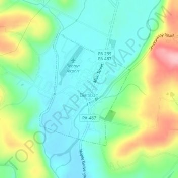
Name: Benton topographic map, elevation, terrain.
Location: Benton, Columbia County, Pennsylvania, 17814, United States (41.18751 -76.39353 41.20431 -76.37548)
Average elevation: 273 m
Minimum elevation: 223 m
Maximum elevation: 379 m
Make a donation
Gear up for your next adventure:
As an Amazon Associate, this site earns from qualifying purchases at no extra cost to you.
Other topographic maps
Click on a map to view its topography, its elevation and its terrain.
Grassmere Park
United States > Pennsylvania > Columbia County > Sugarloaf Township
Average elevation: 355 m
Elk Grove
United States > Pennsylvania > Columbia County > Sugarloaf Township
Average elevation: 534 m