Geolocate

Idstein topographic map

Click on the map to display elevation.

About this map

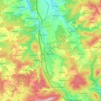
Name: Idstein topographic map, elevation, terrain.

Location: Idstein, Rheingau-Taunus-Kreis, Hesse, 65510, Germany (50.17229 8.20191 50.27871 8.40596)

Average elevation: 354 m

Minimum elevation: 195 m

Maximum elevation: 588 m

Other topographic maps

Click on a map to view its topography, its elevation and its terrain.

Dickschied

Germany > Hesse > Rheingau-Taunus-Kreis

Average elevation: 358 m

Hohe Wurzel

Germany > Hesse > Rheingau-Taunus-Kreis > Taunusstein

Average elevation: 509 m

Gear up for your next adventure:

🦯Trekking Poles - Reduced impact on joints for steep topographic climbs
🥫Freeze-Dried Meals - Lightweight, high-calorie nutrition for multi-day treks
🥾All-Terrain Hiking Boots - Versatile boots for varied hiking conditions
🔨Vehicle Emergency Tool - Safety tool for remote road trips to trailheads
🧴Outdoor Sunscreen - High SPF protection for high-altitude UV exposure

As an Amazon Associate, this site earns from qualifying purchases at no extra cost to you.