Geolocate

Stateline topographic map

Click on the map to display elevation.

About this map

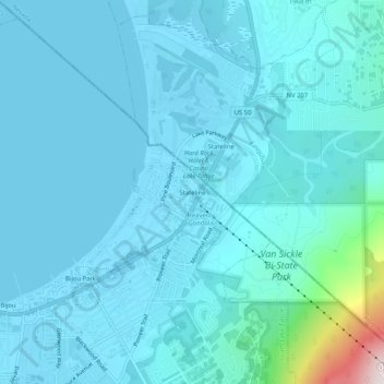
Name: Stateline topographic map, elevation, terrain.

Location: Stateline, South Lake Tahoe, El Dorado County, California, 96151, United States (38.93824 -119.96379 38.97824 -119.92379)

Average elevation: 1,978 m

Minimum elevation: 1,897 m

Maximum elevation: 2,793 m

Other topographic maps

Click on a map to view its topography, its elevation and its terrain.

Gear up for your next adventure:

Bushcraft Tarp - Versatile emergency shelter or gear protection
🧦Hiking Socks - Moisture-wicking and comfortable socks for long hikes
🚲Bike Repair Kit - Essential tools for on-trail mechanical issues
📷Outdoor Action Camera - Capture high-elevation views and rugged adventures
🥘Camping Cookware Set - Compact nesting pots and pans for trail cooking

As an Amazon Associate, this site earns from qualifying purchases at no extra cost to you.