Geolocate

Aschersleben topographic map

Click on the map to display elevation.

About this map

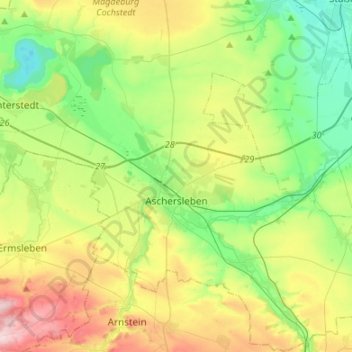
Name: Aschersleben topographic map, elevation, terrain.

Location: Aschersleben, Salzlandkreis, Saxony-Anhalt, 06449, Germany (51.68462 11.37630 51.85060 11.63594)

Average elevation: 143 m

Minimum elevation: 54 m

Maximum elevation: 306 m

Other topographic maps

Click on a map to view its topography, its elevation and its terrain.

Lust

Germany > Saxony-Anhalt > Salzlandkreis > Staßfurt

Average elevation: 71 m

Cochstedt

Germany > Saxony-Anhalt > Salzlandkreis

Average elevation: 135 m

Gear up for your next adventure:

🏕️Camping Hammock - Integrated protection for sleeping between trees
🧢Beanie Hat - Keep your head warm in cold weather
🧴Outdoor Sunscreen - High SPF protection for high-altitude UV exposure
👟Sport Hiking Sandals - Breathable footwear for water crossings and camp rest
🔭Compact Binoculars - Lightweight optics for scouting trails and wildlife

As an Amazon Associate, this site earns from qualifying purchases at no extra cost to you.