Geolocate

Insua topographic map

Click on the map to display elevation.

About this map

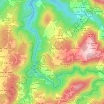
Name: Insua topographic map, elevation, terrain.

Location: Insua, Ortigueira, Ortegal, La Coruña, Galicia, 15330, España (43.56546 -7.91259 43.60546 -7.87259)

Average elevation: 224 m

Minimum elevation: 56 m

Maximum elevation: 397 m

Other topographic maps

Click on a map to view its topography, its elevation and its terrain.

Barbos

España > Galicia > Ortegal > Ortigueira

Average elevation: 110 m

O Ermo

España > Galicia > Ortegal > Ortigueira

Average elevation: 215 m

Insua

España > Galicia > Ortegal > Ortigueira

Average elevation: 269 m

Devesos

España > Galicia > Ortegal > Ortigueira

Average elevation: 301 m

Meixido-Freires

España > Galicia > Ortegal > Ortigueira > A Pradia

Average elevation: 200 m

Gear up for your next adventure:

🧣Merino Neck Gaiter - Protects against wind, sun, and cold at high altitudes
🧴Sunscreen SPF - Broad-spectrum sunscreen for outdoor activities
🥾Hiking Leggings - Comfortable leggings for outdoor activities
🧰Multitool Knife - Compact and versatile tool for outdoor use
🚲Heavy Duty Bike Lock - Secure your bike at the trailhead or during stops

As an Amazon Associate, this site earns from qualifying purchases at no extra cost to you.