Geolocate

Santo Tomas topographic map

Click on the map to display elevation.

About this map

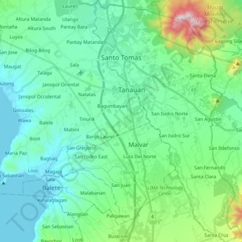
Name: Santo Tomas topographic map, elevation, terrain.

Location: Santo Tomas, Batangas, Calabarzon, 4234, Philippines (13.97963 121.12502 14.14734 121.23197)

Average elevation: 210 m

Minimum elevation: 0 m

Maximum elevation: 1,073 m

Other topographic maps

Click on a map to view its topography, its elevation and its terrain.

Balitoc

Philippines > Batangas > Calatagan

Average elevation: 13 m

Talisay

Philippines > Batangas > Lipa

Average elevation: 363 m

Poblacion

Philippines > Batangas > Taal

Average elevation: 26 m

Fabrica

Philippines > Batangas > Lobo

Average elevation: 20 m

Malaking Pulo

Philippines > Batangas > Tanauan

Average elevation: 178 m

Palsara

Philippines > Batangas > Balete

Average elevation: 58 m

Calle

Philippines > Batangas > Tanauan

Average elevation: 150 m

San Pedro II

Philippines > Batangas > Malvar

Average elevation: 174 m

Talahib Pandayan

Philippines > Batangas > Batangas City

Average elevation: 60 m

Dayap

Philippines > Batangas > Nasugbu

Average elevation: 43 m

Gear up for your next adventure:

👟Trail Running Shoes - Agile footwear for fast-paced topographic exploration
🛏️Sleeping Bag - Warm and compact sleeping bags for outdoor camping
🥤Collapsible Travel Cup - Saves space and weight in your mess kit
🔋Solar Power Bank - Keep your GPS and devices charged during long outdoor trips
🔦LED Headlamp - Hands-free lighting for early morning starts or late finishes

As an Amazon Associate, this site earns from qualifying purchases at no extra cost to you.