Geolocate

Layang topographic map

Click on the map to display elevation.

About this map

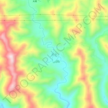
Name: Layang topographic map, elevation, terrain.

Location: Layang, Wangmo, Qianxinan, Guizhou, China (25.10430 106.20100 25.14430 106.24100)

Average elevation: 714 m

Minimum elevation: 517 m

Maximum elevation: 978 m

Gear up for your next adventure:

🧦Thermal Socks - Warm socks for winter hiking or camping
🧢Outdoor Cap - Protective cap for sun and rain during hikes
💡LED Camping Lantern - Illuminate your campsite with long-lasting lanterns
Tent Footprint - Protect tent floor and increase durability
🔦LED Flashlight - Powerful and long-lasting flashlight for camping and emergencies

As an Amazon Associate, this site earns from qualifying purchases at no extra cost to you.