
Make a donation
Gear up for your next adventure:
As an Amazon Associate, this site earns from qualifying purchases at no extra cost to you.
Voesch topographic map
Click on the map to display elevation.
Make a donation
Gear up for your next adventure:
As an Amazon Associate, this site earns from qualifying purchases at no extra cost to you.
About this map
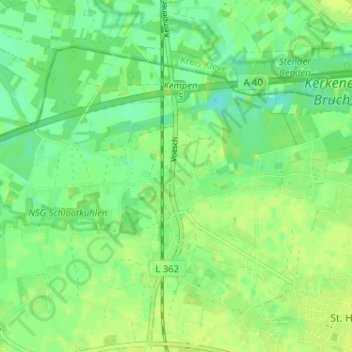
Name: Voesch topographic map, elevation, terrain.
Average elevation: 33 m
Minimum elevation: 24 m
Maximum elevation: 38 m
Make a donation
Gear up for your next adventure:
As an Amazon Associate, this site earns from qualifying purchases at no extra cost to you.
Other topographic maps
Click on a map to view its topography, its elevation and its terrain.
Burg Kempen
Deutschland > Nordrhein-Westfalen > Kreis Viersen > Kempen
Der Westflügel der Burg ist der längere der beiden Trakte. Er ist etwa 46,5 Meter breit und 12 Meter tief. Seine Höhe beträgt – gemessen von der Sohle des Burggrabens – bis zum Spitzbogenfries rund 15 Meter. Im ersten Ober- sowie im Erdgeschoss besitzt er Quer- und Kreuzstockfenster, deren einstige…
Average elevation: 37 m