
Make a donation
Gear up for your next adventure:
As an Amazon Associate, this site earns from qualifying purchases at no extra cost to you.
Obermaubach topographic map
Click on the map to display elevation.
Make a donation
Gear up for your next adventure:
As an Amazon Associate, this site earns from qualifying purchases at no extra cost to you.
Obermaubach
Obermaubach liegt am Eifelnordrand in der Rureifel im Naturpark Nordeifel, direkt an der Rur, die dort zum Stausee Obermaubach gestaut wird. Der Ort ist an drei Seiten von Eifelbergen umgeben. Auf den Höhen liegen die Orte Nideggen, Bergstein und Bogheim. Rurabwärts liegt Untermaubach.
Make a donation
Gear up for your next adventure:
As an Amazon Associate, this site earns from qualifying purchases at no extra cost to you.
About this map
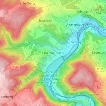
Name: Obermaubach topographic map, elevation, terrain.
Average elevation: 265 m
Minimum elevation: 153 m
Maximum elevation: 393 m
Make a donation
Gear up for your next adventure:
As an Amazon Associate, this site earns from qualifying purchases at no extra cost to you.
Other topographic maps
Click on a map to view its topography, its elevation and its terrain.
Drover Heide
Deutschland > Nordrhein-Westfalen > Kreis Düren > Kreuzau > Stockheim
Average elevation: 184 m