
Make a donation
Gear up for your next adventure:
As an Amazon Associate, this site earns from qualifying purchases at no extra cost to you.
Albenga topographic map
Click on the map to display elevation.
Make a donation
Gear up for your next adventure:
As an Amazon Associate, this site earns from qualifying purchases at no extra cost to you.
Albenga
The current design is the result of further elevations. The restoration works between 1964 and 1967 brought back the cathedral design to its original medieval aspect. The nearby steeple was attached to the church in the 13th century, built over the ruins of the old bell tower between the years 1391 and 1395. This construction is one of the last local examples of the use of bare bricks, progressively replaced by plastering.
Make a donation
Gear up for your next adventure:
As an Amazon Associate, this site earns from qualifying purchases at no extra cost to you.
About this map
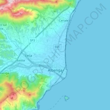
Name: Albenga topographic map, elevation, terrain.
Location: Albenga, Savona, Liguria, Italy (44.02287 8.09942 44.10121 8.22985)
Average elevation: 85 m
Minimum elevation: -1 m
Maximum elevation: 761 m
Make a donation
Gear up for your next adventure:
As an Amazon Associate, this site earns from qualifying purchases at no extra cost to you.