Geolocate

Portlaoise topographic map

Click on the map to display elevation.

About this map
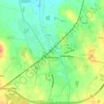
Name: Portlaoise topographic map, elevation, terrain.

Location: Portlaoise, The Municipal District of Portlaoise, County Laois, Leinster, Ireland (53.01759 -7.33080 53.05539 -7.25319)

Average elevation: 101 m

Minimum elevation: 81 m

Maximum elevation: 131 m

Other topographic maps

Click on a map to view its topography, its elevation and its terrain.

Timahoe

Ireland > County Laois

Average elevation: 146 m

Newtown

Ireland > County Laois

Average elevation: 187 m

Timahoe Round Tower

Ireland > County Laois

Average elevation: 137 m

Cullenagh Mountain

Ireland > County Laois

Average elevation: 226 m

Glasha

Ireland > County Laois

Average elevation: 58 m

Sheffield Cross

Ireland > County Laois

Average elevation: 119 m

Rosenallis

Ireland > County Laois

Average elevation: 114 m

Knockardagur

Ireland > County Laois

Average elevation: 248 m

Gear up for your next adventure:

🧰Multitool Knife - Compact and versatile tool for outdoor use
🌬️Windproof Camp Stove - Efficient cooking even on exposed mountain peaks
🎒Hiking Backpack - Lightweight and ergonomic backpacks for day hikes or multi-day treks
🌡️Emergency Mylar Blankets - Compact thermal protection for unexpected nights outdoors
👟Sport Hiking Sandals - Breathable footwear for water crossings and camp rest

As an Amazon Associate, this site earns from qualifying purchases at no extra cost to you.