
Kitzen topographic map
Click on the map to display elevation.
About this map
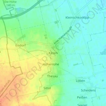
Name: Kitzen topographic map, elevation, terrain.
Location: Kitzen, Pegau, Landkreis Leipzig, Sachsen, 04523, Deutschland (51.20200 12.20332 51.24200 12.24332)
Average elevation: 138 m
Minimum elevation: 125 m
Maximum elevation: 162 m
Other topographic maps
Click on a map to view its topography, its elevation and its terrain.
Kitzen
Deutschland > Sachsen > Landkreis Leipzig > Pegau
Die Ortschaft wurde im Süden von einem schon gefluteten Tagebaurestloch begrenzt. Östlich befand sich der Zwenkauer Tagebau. Dieser wurde 1999 aufgelassen. Hier entstand der Zwenkauer See, der 2015 zur touristischen Nutzung freigegeben wurde. Die Nachbarorte sind im Norden Markranstädt, im Osten Leipzig und…
Average elevation: 137 m