
La Navata topographic map
Click on the map to display elevation.
About this map
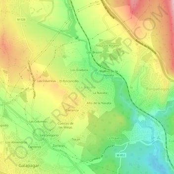
Name: La Navata topographic map, elevation, terrain.
Location: La Navata, Galapagar, Comunidad de Madrid, 28420, España (40.57548 -4.00612 40.61548 -3.96612)
Average elevation: 874 m
Minimum elevation: 774 m
Maximum elevation: 989 m
Other topographic maps
Click on a map to view its topography, its elevation and its terrain.
Monte Público Granja y Molino de la Hoz
España > Comunidad de Madrid > Galapagar
Average elevation: 664 m