
Make a donation
Gear up for your next adventure:
As an Amazon Associate, this site earns from qualifying purchases at no extra cost to you.
Poros topographic map
Click on the map to display elevation.
Make a donation
Gear up for your next adventure:
As an Amazon Associate, this site earns from qualifying purchases at no extra cost to you.
Poros
The land area of the municipality is 49.582 square kilometres (19.144 sq mi). This includes the islands and part of the adjacent Peloponnese coast, adjacent to Galatas, Thermisia and the island of Hydra. The landscape is very hilly and mountainous. The highest peak is the Vigla (358 m) in the west-central part. Following the island's topography and geology, small creeks and seasonal streams flow through steep valleys of the southern and northeastern part. The western and northern part of the island feature smooth hills and shallow valleys. Sandy beaches are restricted to the southern shore of the island, except for a bay in the northern part called Vayionia.
Make a donation
Gear up for your next adventure:
As an Amazon Associate, this site earns from qualifying purchases at no extra cost to you.
About this map
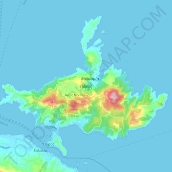
Name: Poros topographic map, elevation, terrain.
Average elevation: 31 m
Minimum elevation: -1 m
Maximum elevation: 351 m
Make a donation
Gear up for your next adventure:
As an Amazon Associate, this site earns from qualifying purchases at no extra cost to you.