
Hamelin topographic map
Click on the map to display elevation.
About this map
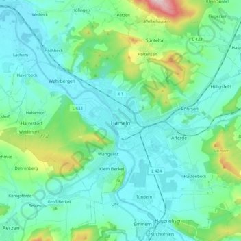
Name: Hamelin topographic map, elevation, terrain.
Location: Hamelin, Landkreis Hameln-Pyrmont, Lower Saxony, Germany (52.04293 9.25920 52.16757 9.46170)
Average elevation: 122 m
Minimum elevation: 58 m
Maximum elevation: 411 m
Other topographic maps
Click on a map to view its topography, its elevation and its terrain.
Pötzen
Germany > Lower Saxony > Landkreis Hameln-Pyrmont > Hessisch Oldendorf
Average elevation: 200 m