
Thank you for supporting this site ❤️
Make a donation
Make a donation
Gear up for your next adventure:
As an Amazon Associate, this site earns from qualifying purchases at no extra cost to you.
Leuscheid topographic map
Click on the map to display elevation.
Thank you for supporting this site ❤️
Make a donation
Make a donation
Gear up for your next adventure:
As an Amazon Associate, this site earns from qualifying purchases at no extra cost to you.
Leuscheid
Leuscheid ist ein evangelisches Kirchdorf in der Gemeinde Windeck im Rhein-Sieg-Kreis in Nordrhein-Westfalen. Der Ort liegt auf dem gleichnamigen Höhenzug Leuscheid.
Thank you for supporting this site ❤️
Make a donation
Make a donation
Gear up for your next adventure:
As an Amazon Associate, this site earns from qualifying purchases at no extra cost to you.
About this map
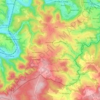
Name: Leuscheid topographic map, elevation, terrain.
Average elevation: 235 m
Minimum elevation: 86 m
Maximum elevation: 378 m
Thank you for supporting this site ❤️
Make a donation
Make a donation
Gear up for your next adventure:
As an Amazon Associate, this site earns from qualifying purchases at no extra cost to you.