Geolocate

Alupay topographic map

Click on the map to display elevation.

About this map

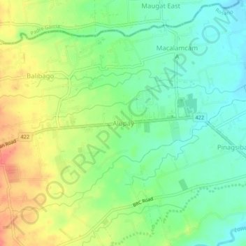
Name: Alupay topographic map, elevation, terrain.

Location: Alupay, Rosario, Batangas, Calabarzon, 4225, Philippines (13.82441 121.27649 13.86441 121.31649)

Average elevation: 73 m

Minimum elevation: 47 m

Maximum elevation: 110 m

Other topographic maps

Click on a map to view its topography, its elevation and its terrain.

Pinagsibaan

Philippines > Batangas > Rosario

Average elevation: 57 m

Gear up for your next adventure:

🧣Merino Neck Gaiter - Protects against wind, sun, and cold at high altitudes
🚲Heavy Duty Bike Lock - Secure your bike at the trailhead or during stops
🧭Orienteering Kit - Tools for map reading and navigation in the wild
🧢Sun Protection Cap - Breathable cap to protect from sun exposure
🪑Ultralight Camping Stool - Compact seating for rest stops during long hikes

As an Amazon Associate, this site earns from qualifying purchases at no extra cost to you.