Geolocate

Sambhal topographic map

Click on the map to display elevation.

About this map

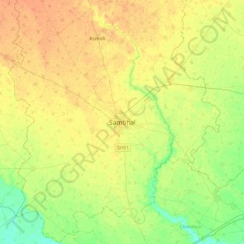
Name: Sambhal topographic map, elevation, terrain.

Location: Sambhal, Uttar Pradesh, 244302, India (28.42520 78.41093 28.74520 78.73093)

Average elevation: 198 m

Minimum elevation: 183 m

Maximum elevation: 210 m

Gear up for your next adventure:

🧶550 Survival Paracord - Versatile utility cord for emergency repairs and rigging
🕯️Camping Lantern - Illuminates your entire campsite with high-efficiency LEDs
🥾Trekking Boots - Durable boots for long-distance trekking
🧦Hiking Socks - Moisture-wicking and comfortable socks for long hikes
🥾Trail Running Boots - Durable shoes designed for trail running

As an Amazon Associate, this site earns from qualifying purchases at no extra cost to you.