Geolocate

Rosman topographic map

Click on the map to display elevation.

About this map

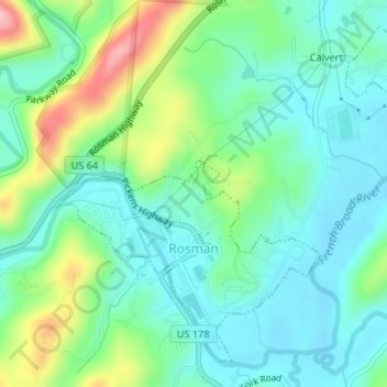
Name: Rosman topographic map, elevation, terrain.

Location: Rosman, Transylvania County, North Carolina, United States (35.13575 -82.83366 35.15925 -82.80299)

Average elevation: 703 m

Minimum elevation: 657 m

Maximum elevation: 821 m

Other topographic maps

Click on a map to view its topography, its elevation and its terrain.

Gear up for your next adventure:

🧤Thermal Hiking Gloves - Grip-enhanced gloves for cold-weather altitude trekking
🌡️Emergency Mylar Blankets - Compact thermal protection for unexpected nights outdoors
🪑Ultralight Camping Stool - Compact seating for rest stops during long hikes
🧣Evaporative Cooling Towel - Beat the heat during intense summer climbs
🕶️Polarized Sunglasses - Protect your eyes with durable polarized lenses

As an Amazon Associate, this site earns from qualifying purchases at no extra cost to you.