Geolocate

Jhang topographic map

Click on the map to display elevation.

Jhang

Jhang Sadr is located at 31.27 latitude and 72.33 longitude and is situated at an elevation of 158 meters above sea level.

Wikipedia (CC-BY-SA 3.0)

About this map

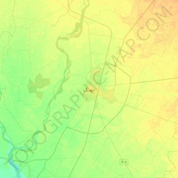
Name: Jhang topographic map, elevation, terrain.

Location: Jhang, Jhang Tehsil, Jhang District, Faisalabad Division, Punjab, 08871, Pakistan (31.11288 72.15031 31.43288 72.47031)

Average elevation: 157 m

Minimum elevation: 145 m

Maximum elevation: 165 m

Other topographic maps

Click on a map to view its topography, its elevation and its terrain.

Faisalabad City Tehsil

Pakistan > Punjab

The soil consists of young stratified silt loam or very fine sand loam which makes the subsoil weak in structure with common kankers at only five feet. The course of the rivers within Faisalabad is winding and often subject to frequent alternations. In the rainy season, the currents are very strong. This leads…

Average elevation: 185 m

Mansoora Abad

Pakistan > Punjab

Average elevation: 187 m

Dharamkot

Pakistan > Punjab

Average elevation: 231 m

Lahore District

Pakistan > Punjab

Average elevation: 213 m

Gear up for your next adventure:

🥾Trail Hiking Boots - Supportive boots for rough trails
🍽️Titanium Camping Spork - Ultralight and indestructible eating utensil
🥾Durable Hiking Shoes - Long-lasting shoes for frequent hiking
💧Collapsible Water Bottle - Space-saving water bottle for outdoor activities
🧦Crew Hiking Socks - Comfortable socks for long-distance hikes

As an Amazon Associate, this site earns from qualifying purchases at no extra cost to you.