Geolocate

La Punta topographic map

Click on the map to display elevation.

About this map

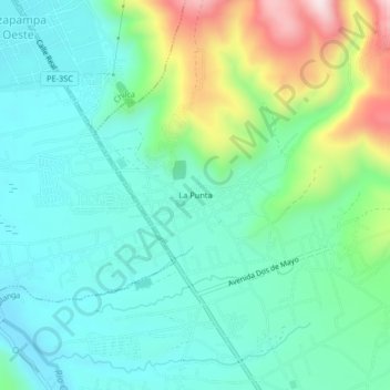
Name: La Punta topographic map, elevation, terrain.

Location: La Punta, Sapallanga, Huancayo, Junín, Perú (-12.13450 -75.19532 -12.09450 -75.15532)

Average elevation: 3,340 m

Minimum elevation: 3,215 m

Maximum elevation: 3,695 m

Gear up for your next adventure:

Camping Coffee Maker - Brew fresh coffee anywhere on the topographic map
🧶550 Survival Paracord - Versatile utility cord for emergency repairs and rigging
🥤Collapsible Travel Cup - Saves space and weight in your mess kit
🧴Insect Repellent - Protect yourself from bugs during outdoor adventures
🔋Solar Power Bank - Keep your GPS and devices charged during long outdoor trips

As an Amazon Associate, this site earns from qualifying purchases at no extra cost to you.