
Make a donation
Gear up for your next adventure:
As an Amazon Associate, this site earns from qualifying purchases at no extra cost to you.
Damascus topographic map
Click on the map to display elevation.
Make a donation
Gear up for your next adventure:
As an Amazon Associate, this site earns from qualifying purchases at no extra cost to you.
Damascus
As an unincorporated area, Damascus' boundaries are not officially defined. Damascus is recognized by the United States Census Bureau as a census-designated place, and by the United States Geological Survey as a populated place located at 39°16′16″N 77°12′22″W / 39.27111°N 77.20611°W / 39.27111; -77.20611 (39.271040, −77.206098). Damascus has the highest point in the county at 866 ft (264m) above sea level. It is also the highest elevation in the immediately adjacent Washington D.C. suburbs.
Make a donation
Gear up for your next adventure:
As an Amazon Associate, this site earns from qualifying purchases at no extra cost to you.
About this map
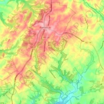
Name: Damascus topographic map, elevation, terrain.
Location: Damascus, Montgomery County, Maryland, 20872, United States (39.23894 -77.23628 39.30973 -77.16107)
Average elevation: 202 m
Minimum elevation: 132 m
Maximum elevation: 260 m
Make a donation
Gear up for your next adventure:
As an Amazon Associate, this site earns from qualifying purchases at no extra cost to you.