
Make a donation
Gear up for your next adventure:
As an Amazon Associate, this site earns from qualifying purchases at no extra cost to you.
Sint-Joris topographic map
Click on the map to display elevation.
Make a donation
Gear up for your next adventure:
As an Amazon Associate, this site earns from qualifying purchases at no extra cost to you.
Sint-Joris
Sint-Joris ligt in Zandig Vlaanderen op een hoogte van ongeveer 12 meter. De plaats ligt aan het Kanaal Gent-Brugge. De Miseriebocht is een natuurgebied dat in 1987 is ontstaan nadat een bocht in het kanaal werd rechtgetrokken, en dat ligt tussen de oude loop en de nieuwe loop van het kanaal in.
Make a donation
Gear up for your next adventure:
As an Amazon Associate, this site earns from qualifying purchases at no extra cost to you.
About this map
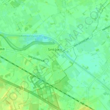
Name: Sint-Joris topographic map, elevation, terrain.
Location: Sint-Joris, Beernem, Brugge, West-Vlaanderen, Vlaanderen, België (51.10602 3.34179 51.14408 3.39015)
Average elevation: 11 m
Minimum elevation: 3 m
Maximum elevation: 20 m
Make a donation
Gear up for your next adventure:
As an Amazon Associate, this site earns from qualifying purchases at no extra cost to you.
Other topographic maps
Click on a map to view its topography, its elevation and its terrain.