
Thank you for supporting this site ❤️
Make a donation
Make a donation
Gear up for your next adventure:
As an Amazon Associate, this site earns from qualifying purchases at no extra cost to you.
Verlaguet topographic map
Click on the map to display elevation.
Thank you for supporting this site ❤️
Make a donation
Make a donation
Gear up for your next adventure:
As an Amazon Associate, this site earns from qualifying purchases at no extra cost to you.
About this map
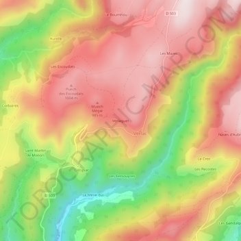
Name: Verlaguet topographic map, elevation, terrain.
Average elevation: 825 m
Minimum elevation: 486 m
Maximum elevation: 1,069 m
Thank you for supporting this site ❤️
Make a donation
Make a donation
Gear up for your next adventure:
As an Amazon Associate, this site earns from qualifying purchases at no extra cost to you.
Other topographic maps
Click on a map to view its topography, its elevation and its terrain.
Saint-Geniez-d'Olt
France > Occitanie > Aveyron > Saint Geniez d'Olt et d'Aubrac
Average elevation: 614 m
Aurelle-Verlac
France > Occitanie > Aveyron > Saint Geniez d'Olt et d'Aubrac
Average elevation: 1,119 m