

Arette topographic map
Click on the map to display elevation.
Arette
Arette is a very large commune and has a land area of 92 km2. It is also mountainous (the La Pierre Saint-Martin ski resort is within its borders, for example) and its highest peak is the 2,315 m Soum Couy, which is situated not far from the 2,504 m Pic d'Anie, the highest peak in the western Pyrenees. From Pic d'Anie the mountain range extends downwards for approximately 20 km, forming both sides of the Aspe Valley to the north-west. The Vert d'Arette (a tributary of the Vert) flows through this valley. The ancient village (also named Arette) from which the commune extends is located at an altitude of 316 m in the valley of Barétous, which lies between the aforementioned Aspe valley, to its east, and the Basque province of Soule, to its west.
About this map
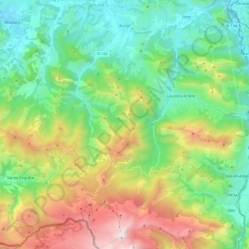
Name: Arette topographic map, elevation, terrain.
Average elevation: 912 m
Minimum elevation: 253 m
Maximum elevation: 2,304 m
Other topographic maps
Click on a map to view its topography, its elevation and its terrain.
Urdazuri
France > Nouvelle-Aquitaine > Pyrénées-Atlantiques > Saint-Jean-de-Luz
Average elevation: 23 m

Coustères
France > Nouvelle-Aquitaine > Pyrénées-Atlantiques > Salies-de-Béarn
Average elevation: 81 m


Larroinea
France > Nouvelle-Aquitaine > Pyrénées-Atlantiques > Saint-Jean-Pied-de-Port
Average elevation: 204 m
Izpegi
France > Nouvelle-Aquitaine > Pyrénées-Atlantiques > Saint-Étienne-de-Baïgorry
Average elevation: 632 m

Château-Observatoire Abbadia
France > Nouvelle-Aquitaine > Pyrénées-Atlantiques > Hendaye > Sopite
Average elevation: 25 m


Pic d'Orisson / Harburu
France > Nouvelle-Aquitaine > Pyrénées-Atlantiques > Saint-Michel
Average elevation: 817 m
Agerreko Larrea
France > Nouvelle-Aquitaine > Pyrénées-Atlantiques > Mouguerre
Average elevation: 39 m
Pic d'Orisson / Harburu
France > Nouvelle-Aquitaine > Pyrénées-Atlantiques > Saint-Michel
Average elevation: 817 m