Geolocate

Dinapigue topographic map

Click on the map to display elevation.

About this map

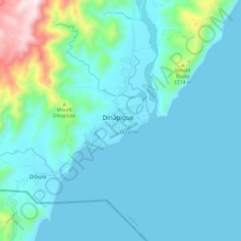
Name: Dinapigue topographic map, elevation, terrain.

Location: Dinapigue, Isabela, Cagayan Valley, Philippines (16.48488 122.22313 16.56488 122.30313)

Average elevation: 104 m

Minimum elevation: -1 m

Maximum elevation: 730 m

Gear up for your next adventure:

Camping Tent - Weather-resistant tents suitable for 2 to 6 people
🛰️Satellite Messenger - Emergency communication for areas with no cell service
🎒Hiking Backpack - Lightweight and ergonomic backpacks for day hikes or multi-day treks
🔦LED Headtorch - Bright and durable light for night activities
🧥Softshell Jacket - Windproof and breathable jacket for hiking

As an Amazon Associate, this site earns from qualifying purchases at no extra cost to you.