
Make a donation
Gear up for your next adventure:
As an Amazon Associate, this site earns from qualifying purchases at no extra cost to you.
Blois topographic map
Click on the map to display elevation.
Make a donation
Gear up for your next adventure:
As an Amazon Associate, this site earns from qualifying purchases at no extra cost to you.
About this map
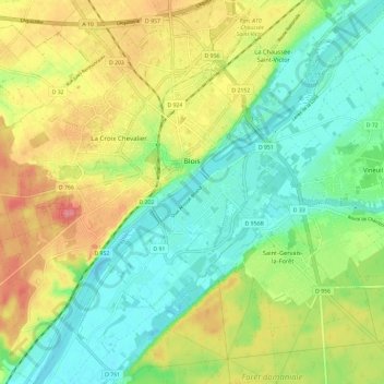
Name: Blois topographic map, elevation, terrain.
Average elevation: 95 m
Minimum elevation: 63 m
Maximum elevation: 142 m
Make a donation
Gear up for your next adventure:
As an Amazon Associate, this site earns from qualifying purchases at no extra cost to you.
Other topographic maps
Click on a map to view its topography, its elevation and its terrain.
Plateau de Bel-Air
France > Centre-Val de Loire > Loir-et-Cher > Saint-Ouen > Côte de Bel-Air
Average elevation: 105 m
Make a donation
Gear up for your next adventure:
As an Amazon Associate, this site earns from qualifying purchases at no extra cost to you.
Rigaudon
France > Centre-Val de Loire > Loir-et-Cher > Montrichard Val de Cher
Average elevation: 97 m
La Pente de l'Aigri
France > Centre-Val de Loire > Loir-et-Cher > Saint-Georges-sur-Cher
Average elevation: 99 m
Chouzy
France > Centre-Val de Loire > Loir-et-Cher > La Chapelle-Saint-Martin-en-Plaine
Average elevation: 115 m
Make a donation
Gear up for your next adventure:
As an Amazon Associate, this site earns from qualifying purchases at no extra cost to you.
La Batardière
France > Centre-Val de Loire > Loir-et-Cher > Montrichard Val de Cher
Average elevation: 99 m