Geolocate

Distrito Sur topographic map

Click on the map to display elevation.

About this map

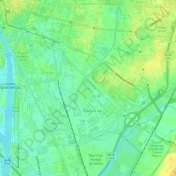
Name: Distrito Sur topographic map, elevation, terrain.

Location: Distrito Sur, Sevilla, Andalucía, España (37.35284 -5.99235 37.38120 -5.93859)

Average elevation: 12 m

Minimum elevation: 2 m

Maximum elevation: 23 m

Other topographic maps

Click on a map to view its topography, its elevation and its terrain.

Dehesa de Tablada

España > Andalucía > Sevilla

Average elevation: 8 m

Río Guadaira

España > Andalucía > Sevilla

Average elevation: 10 m

Jardines del Valle

España > Andalucía > Sevilla

Average elevation: 15 m

Gear up for your next adventure:

💡Compact LED Flashlight - Powerful and portable flashlight for outdoor use
🕯️Camping Lantern - Illuminates your entire campsite with high-efficiency LEDs
💧Hydration Bladder - Hands-free hydration solution for long treks
🥾Approach Boots - Comfortable boots for hiking and climbing approaches
🌡️Emergency Mylar Blankets - Compact thermal protection for unexpected nights outdoors

As an Amazon Associate, this site earns from qualifying purchases at no extra cost to you.