Geolocate

McGill topographic map

Click on the map to display elevation.

About this map

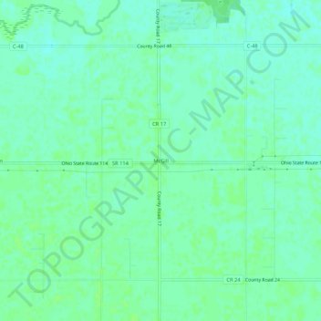
Name: McGill topographic map, elevation, terrain.

Location: McGill, Paulding County, Ohio, United States (40.99894 -84.79413 41.03894 -84.75413)

Average elevation: 233 m

Minimum elevation: 228 m

Maximum elevation: 236 m

Other topographic maps

Click on a map to view its topography, its elevation and its terrain.

Payne

United States > Ohio > Paulding County

Average elevation: 228 m

Scott

United States > Ohio > Paulding County

Average elevation: 226 m

Grover Hill

United States > Ohio > Paulding County

Average elevation: 222 m

Payne

United States > Ohio > Paulding County

Average elevation: 228 m

Gear up for your next adventure:

🥽Outdoor Goggles - Protective eyewear for outdoor activities
🧦Merino Wool Socks - Moisture-wicking comfort for long-distance hiking
🧤Insulated Winter Gloves - Heavy-duty protection for sub-zero Canadian adventures
Tent Footprint - Protect tent floor and increase durability
🚲MTB Frame Bag - Carry tools and maps directly on your bicycle frame

As an Amazon Associate, this site earns from qualifying purchases at no extra cost to you.