
Make a donation
Gear up for your next adventure:
As an Amazon Associate, this site earns from qualifying purchases at no extra cost to you.
Statiewijk topographic map
Click on the map to display elevation.
Make a donation
Gear up for your next adventure:
As an Amazon Associate, this site earns from qualifying purchases at no extra cost to you.
About this map
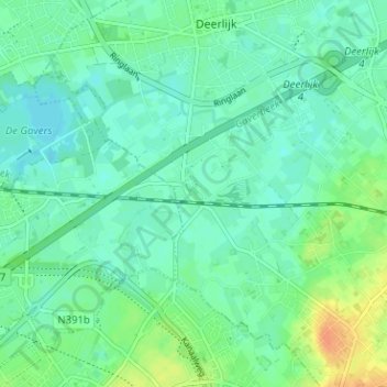
Name: Statiewijk topographic map, elevation, terrain.
Average elevation: 17 m
Minimum elevation: 7 m
Maximum elevation: 40 m
Make a donation
Gear up for your next adventure:
As an Amazon Associate, this site earns from qualifying purchases at no extra cost to you.
Other topographic maps
Click on a map to view its topography, its elevation and its terrain.
Deerlijk
België > West-Vlaanderen > Kortrijk > Deerlijk
Door afnemende afzetmarkten en goedkoper machinaal geweven textiel uit Engeland kende de linnennijverheid tijdens de Nederlandse periode (1815-1830) een grote neergang. Tussen 1840 en 1850 kwam deze crisis tot een hoogtepunt. Daarenboven werd de gemeente getroffen door een hongersnood door mislukte aardappel-…
Average elevation: 18 m