Geolocate

Oxley topographic map

Click on the map to display elevation.

About this map
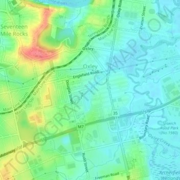
Name: Oxley topographic map, elevation, terrain.

Location: Oxley, Logan City, Brisbane, Queensland, Australia (-27.57819 152.95900 -27.54385 152.99308)

Average elevation: 23 m

Minimum elevation: 2 m

Maximum elevation: 71 m

Other topographic maps

Click on a map to view its topography, its elevation and its terrain.
Logan City

Australia > Queensland > Logan City

Average elevation: 30 m

Greenbank

Australia > Queensland > Logan City > Greenbank

Average elevation: 56 m

Eurora Park

Australia > Queensland > Logan City

Average elevation: 18 m

Slacks Creek

Australia > Queensland > Logan City

Average elevation: 18 m

Logan River

Australia > Queensland > Logan City

Average elevation: 11 m

Flagstone

Australia > Queensland > Logan City > Flagstone

Average elevation: 44 m

Pakenham Park

Australia > Queensland > Logan City

Average elevation: 69 m

Greenbank pony club

Australia > Queensland > Logan City

Average elevation: 49 m

Gear up for your next adventure:

🧭Orienteering Kit - Tools for map reading and navigation in the wild
💧Collapsible Water Bottle - Space-saving water bottle for outdoor activities
🧭GPS Handheld Device - Reliable GPS navigation for outdoor adventures
🧊Insulated Water Bottle - Keeps drinks cold in summer and prevents freezing in winter
🧴Insect Repellent - Protect yourself from bugs during outdoor adventures

As an Amazon Associate, this site earns from qualifying purchases at no extra cost to you.