Geolocate

Perkins topographic map

Click on the map to display elevation.

About this map

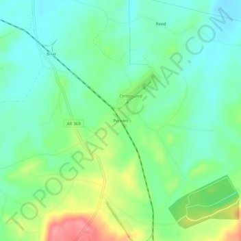
Name: Perkins topographic map, elevation, terrain.

Location: Perkins, Howard County, Arkansas, United States (34.05678 -93.87991 34.09678 -93.83991)

Average elevation: 160 m

Minimum elevation: 130 m

Maximum elevation: 225 m

Other topographic maps

Click on a map to view its topography, its elevation and its terrain.

Mineral Springs

United States > Arkansas > Howard County

Average elevation: 103 m

Dierks

United States > Arkansas > Howard County

Average elevation: 139 m

Gear up for your next adventure:

🧥Softshell Jacket - Windproof and breathable jacket for hiking
🥾Mountain Hiking Shoes - Shoes with superior grip for mountainous terrain
🔭Compact Monocular - One-handed bird watching and trail spotting
💡LED Camping Lantern - Illuminate your campsite with long-lasting lanterns
🎒Hiking Backpack - Lightweight and ergonomic backpacks for day hikes or multi-day treks

As an Amazon Associate, this site earns from qualifying purchases at no extra cost to you.