Geolocate

A Granxa topographic map

Click on the map to display elevation.

About this map
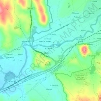
Name: A Granxa topographic map, elevation, terrain.

Location: A Granxa, Distriz, Monforte de Lemos, Tierra de Lemos, Lugo, Galicia, 27419, España (42.48167 -7.57326 42.52167 -7.53326)

Average elevation: 296 m

Minimum elevation: 268 m

Maximum elevation: 369 m

Other topographic maps

Click on a map to view its topography, its elevation and its terrain.

Moreda

España > Galicia > Tierra de Lemos > Monforte de Lemos

Average elevation: 370 m

Caneda

España > Galicia > Tierra de Lemos > Monforte de Lemos

Average elevation: 404 m

Chavaga

España > Galicia > Tierra de Lemos > Monforte de Lemos

Average elevation: 396 m

Distriz

España > Galicia > Tierra de Lemos > Monforte de Lemos

Average elevation: 291 m

Reigada

España > Galicia > Tierra de Lemos > Monforte de Lemos

Average elevation: 342 m

Sindrán

España > Galicia > Tierra de Lemos > Monforte de Lemos

Average elevation: 478 m

Seoane

España > Galicia > Tierra de Lemos > Monforte de Lemos

Average elevation: 325 m

Seoane

España > Galicia > Tierra de Lemos > Monforte de Lemos

Average elevation: 325 m

Gear up for your next adventure:

🦶Anti-Blister Balm - Prevents friction and hotspots during long ascents
🧥Packable Rain Jacket - Breathable waterproof layer for unpredictable weather
🥾Waterproof Trail Shoes - Shoes designed to handle wet terrain
🪑Insulated Seat Pad - Protect your seat from cold rocks and wet logs
🔨Vehicle Emergency Tool - Safety tool for remote road trips to trailheads

As an Amazon Associate, this site earns from qualifying purchases at no extra cost to you.