
Thank you for supporting this site ❤️
Make a donation
Make a donation
Gear up for your next adventure:
As an Amazon Associate, this site earns from qualifying purchases at no extra cost to you.
Bécancour topographic map
Click on the map to display elevation.
Thank you for supporting this site ❤️
Make a donation
Make a donation
Gear up for your next adventure:
As an Amazon Associate, this site earns from qualifying purchases at no extra cost to you.
About this map
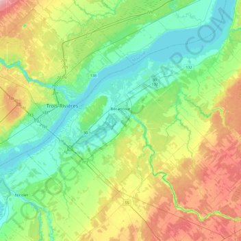
Name: Bécancour topographic map, elevation, terrain.
Location: Bécancour, Bécancour (MRC), Centre-du-Québec, Quebec, Canada (46.19450 -72.61107 46.45232 -72.15862)
Average elevation: 39 m
Minimum elevation: -1 m
Maximum elevation: 120 m
Bécancour (MRC) trails, hiking, mountain biking, running and outdoor activities
Thank you for supporting this site ❤️
Make a donation
Make a donation
Gear up for your next adventure:
As an Amazon Associate, this site earns from qualifying purchases at no extra cost to you.
Other topographic maps
Click on a map to view its topography, its elevation and its terrain.