
Plazoleta Jujuy topographic map
Interactive map
Click on the map to display elevation.
About this map
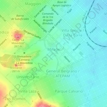
Name: Plazoleta Jujuy topographic map, elevation, terrain.
Average elevation: 209 m
Minimum elevation: 180 m
Maximum elevation: 280 m
Other topographic maps
Click on a map to view its topography, its elevation and its terrain.
San Juan
Argentine > Province de Buenos Aires > Tandil
San Juan, Tandil, Partido de Tandil, Province de Buenos Aires, Argentine
Average elevation: 201 m
Palermo
Argentine > Province de Buenos Aires > Tandil
Palermo, Tandil, Partido de Tandil, Province de Buenos Aires, Argentine
Average elevation: 185 m
Tandil
Argentine > Province de Buenos Aires > Tandil
Tandil, Province de Buenos Aires, Argentine
Average elevation: 228 m