Geolocate

Ferny Grove topographic map

Click on the map to display elevation.

About this map

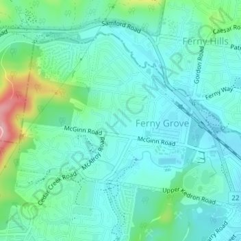
Name: Ferny Grove topographic map, elevation, terrain.

Location: Ferny Grove, City of Brisbane, Queensland, 4055, Australia (-27.41295 152.91464 -27.39333 152.94281)

Average elevation: 77 m

Minimum elevation: 52 m

Maximum elevation: 151 m

Other topographic maps

Click on a map to view its topography, its elevation and its terrain.

Bulimba Creek

Australia > Queensland > City of Brisbane

Average elevation: 11 m

Tangalooma

Australia > Queensland > City of Brisbane

Average elevation: 41 m

Enoggera Hill

Australia > Queensland > City of Brisbane

Average elevation: 114 m

Enoggera Dam

Australia > Queensland > City of Brisbane

Average elevation: 90 m

Blunder Creek

Australia > Queensland > City of Brisbane

Average elevation: 26 m

Tangalooma

Australia > Queensland > City of Brisbane

Average elevation: 41 m

Gear up for your next adventure:

🛌Insulated Sleeping Pad - Critical thermal barrier between you and the cold ground
🧴First Aid Kit - Essential first aid supplies for outdoor emergencies
🚲Handlebar Phone Mount - View topographic-map.com live while cycling
🧭GPS Outdoor Watch - Smart watch for navigation and fitness tracking in nature
🥾Trail Hiking Shoes - Durable shoes designed for rugged trails

As an Amazon Associate, this site earns from qualifying purchases at no extra cost to you.