Geolocate

Manning topographic map

Click on the map to display elevation.

About this map

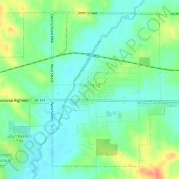
Name: Manning topographic map, elevation, terrain.

Location: Manning, Carroll County, Iowa, United States (41.89571 -95.08538 41.92112 -95.04568)

Average elevation: 415 m

Minimum elevation: 398 m

Maximum elevation: 448 m

Gear up for your next adventure:

🔋Lithium AA Batteries - Long-lasting power that performs in extreme cold
🧭Orienteering Kit - Tools for map reading and navigation in the wild
Camping Essentials - All-in-one gear for a comfortable camping trip
🧴Outdoor Sunscreen - High SPF protection for high-altitude UV exposure
🥾Waterproof Hiking Boots - Essential footwear for rugged terrain and wet Canadian trails

As an Amazon Associate, this site earns from qualifying purchases at no extra cost to you.