
Make a donation
Gear up for your next adventure:
As an Amazon Associate, this site earns from qualifying purchases at no extra cost to you.
Cabudare topographic map
Click on the map to display elevation.
Make a donation
Gear up for your next adventure:
As an Amazon Associate, this site earns from qualifying purchases at no extra cost to you.
Cabudare
Cabudare es una ciudad venezolana, capital del Municipio Palavecino en el Estado Lara, ubicada en la Región Centroccidental en Venezuela. Cabudare cuenta con una población de 206 088 habitantes para 2023. Fue fundada oficialmente como pueblo, bajo la jurisdicción de Barquisimeto en 1817. Cabudare se encuentra a 400 m de altitud en el Río Turbio.
Make a donation
Gear up for your next adventure:
As an Amazon Associate, this site earns from qualifying purchases at no extra cost to you.
About this map
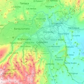
Name: Cabudare topographic map, elevation, terrain.
Average elevation: 637 m
Minimum elevation: 282 m
Maximum elevation: 1,730 m
Make a donation
Gear up for your next adventure:
As an Amazon Associate, this site earns from qualifying purchases at no extra cost to you.
Other topographic maps
Click on a map to view its topography, its elevation and its terrain.