
Thank you for supporting this site ❤️
Make a donation
Make a donation
Gear up for your next adventure:
As an Amazon Associate, this site earns from qualifying purchases at no extra cost to you.
Ohiopyle topographic map
Click on the map to display elevation.
Thank you for supporting this site ❤️
Make a donation
Make a donation
Gear up for your next adventure:
As an Amazon Associate, this site earns from qualifying purchases at no extra cost to you.
About this map
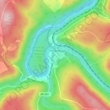
Name: Ohiopyle topographic map, elevation, terrain.
Location: Ohiopyle, Fayette County, Pennsylvania, United States (39.86192 -79.50183 39.87573 -79.48698)
Average elevation: 457 m
Minimum elevation: 338 m
Maximum elevation: 593 m
Thank you for supporting this site ❤️
Make a donation
Make a donation
Gear up for your next adventure:
As an Amazon Associate, this site earns from qualifying purchases at no extra cost to you.
Other topographic maps
Click on a map to view its topography, its elevation and its terrain.
Mill Run
United States > Pennsylvania > Fayette County > Springfield Township
Average elevation: 482 m