
Make a donation
Gear up for your next adventure:
As an Amazon Associate, this site earns from qualifying purchases at no extra cost to you.
Les Adrets topographic map
Click on the map to display elevation.
Make a donation
Gear up for your next adventure:
As an Amazon Associate, this site earns from qualifying purchases at no extra cost to you.
About this map
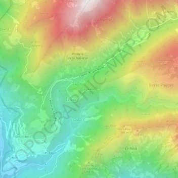
Name: Les Adrets topographic map, elevation, terrain.
Average elevation: 1,179 m
Minimum elevation: 564 m
Maximum elevation: 2,053 m
Make a donation
Gear up for your next adventure:
As an Amazon Associate, this site earns from qualifying purchases at no extra cost to you.
Other topographic maps
Click on a map to view its topography, its elevation and its terrain.
La Gordolasque
France > Provence-Alpes-Côte d'Azur > Alpes-Maritimes > Belvédère
D'une longueur de 18,7 km, elle prend source à 2 675 m d'altitude dans le vallon de la Fous, sur la commune de Belvédère. Elle a aussi pour source secondaire le lac Long (2 566 m), sur la terrasse du Gelas juste en dessous de la Cime du Gelas (3 143 m).
Average elevation: 1,841 m
Gias du Lac Autier
France > Provence-Alpes-Côte d'Azur > Alpes-Maritimes > Belvédère
Average elevation: 2,352 m