
Make a donation
Gear up for your next adventure:
As an Amazon Associate, this site earns from qualifying purchases at no extra cost to you.
Niederdorfelden topographic map
Click on the map to display elevation.
Make a donation
Gear up for your next adventure:
As an Amazon Associate, this site earns from qualifying purchases at no extra cost to you.
Niederdorfelden
Niederdorfelden liegt auf einer Höhe von 111 m über NN, 4 km nordöstlich der Stadtmitte von Bad Vilbel und 12 km nordöstlich der Stadtmitte von Frankfurt am Main.
Make a donation
Gear up for your next adventure:
As an Amazon Associate, this site earns from qualifying purchases at no extra cost to you.
About this map
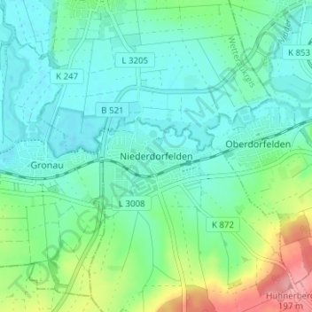
Name: Niederdorfelden topographic map, elevation, terrain.
Location: Niederdorfelden, Main-Kinzig-Kreis, Hessen, 61138, Deutschland (50.17415 8.78304 50.21415 8.82304)
Average elevation: 131 m
Minimum elevation: 105 m
Maximum elevation: 210 m
Make a donation
Gear up for your next adventure:
As an Amazon Associate, this site earns from qualifying purchases at no extra cost to you.
Other topographic maps
Click on a map to view its topography, its elevation and its terrain.