Geolocate

Buda topographic map

Click on the map to display elevation.

About this map

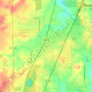
Name: Buda topographic map, elevation, terrain.

Location: Buda, Hays County, Texas, United States (30.03972 -97.90009 30.11415 -97.80917)

Average elevation: 223 m

Minimum elevation: 186 m

Maximum elevation: 263 m

Other topographic maps

Click on a map to view its topography, its elevation and its terrain.

Driftwood

United States > Texas > Hays County

Average elevation: 319 m

Henly

United States > Texas > Hays County

Average elevation: 405 m

Henly

United States > Texas > Hays County

Average elevation: 405 m

Yell

United States > Texas > Hays County

Average elevation: 403 m

Driftwood

United States > Texas > Hays County

Average elevation: 319 m

Gear up for your next adventure:

🥾Hiking Boots - Sturdy boots providing ankle support and traction on rugged trails
🧴Waterproofing Spray - Restore the DWR coating on jackets and tents
🥾Mountaineering Boots - Supportive boots for climbing and high-altitude hiking
🧣Evaporative Cooling Towel - Beat the heat during intense summer climbs
🔭Outdoor Binoculars - Lightweight binoculars for birdwatching and hiking

As an Amazon Associate, this site earns from qualifying purchases at no extra cost to you.