
Make a donation
Gear up for your next adventure:
As an Amazon Associate, this site earns from qualifying purchases at no extra cost to you.
King City topographic map
Click on the map to display elevation.
Make a donation
Gear up for your next adventure:
As an Amazon Associate, this site earns from qualifying purchases at no extra cost to you.
King City
King City (variant: Kings City) is a city in Monterey County, California, United States. King City is located on the Salinas River 51 miles (82 km) southeast of Salinas, at an elevation of 335 feet (102 m). It lies along U.S. Route 101 in the Salinas Valley of the Central Coast. King City is a member of the Association of Monterey Bay Area Governments. The population was 12,874 at the 2010 census. It is a small town which has experienced slow economic growth over the past 50 years.
Make a donation
Gear up for your next adventure:
As an Amazon Associate, this site earns from qualifying purchases at no extra cost to you.
About this map
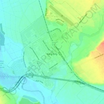
Name: King City topographic map, elevation, terrain.
Average elevation: 102 m
Minimum elevation: 86 m
Maximum elevation: 137 m
Make a donation
Gear up for your next adventure:
As an Amazon Associate, this site earns from qualifying purchases at no extra cost to you.