Geolocate

Schneeberg topographic map

Click on the map to display elevation.

About this map

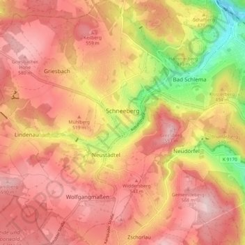
Name: Schneeberg topographic map, elevation, terrain.

Location: Schneeberg, Erzgebirgskreis, Saxony, 08289, Germany (50.56338 12.57566 50.62110 12.66030)

Average elevation: 499 m

Minimum elevation: 327 m

Maximum elevation: 596 m

Gear up for your next adventure:

🥾Trail Hiking Socks - Comfortable socks to prevent blisters and fatigue
🧳Compression Sacks - Maximize space in your backpack by shrinking gear
🧭GPS Outdoor Watch - Smart watch for navigation and fitness tracking in nature
🧦Outdoor Socks - Durable socks designed for hiking and outdoor sports
🧥Waterproof Hiking Jacket - Protect yourself from rain and wind while hiking

As an Amazon Associate, this site earns from qualifying purchases at no extra cost to you.