Geolocate

Trebnitz topographic map

Click on the map to display elevation.

About this map

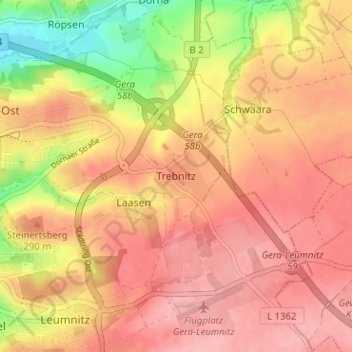
Name: Trebnitz topographic map, elevation, terrain.

Location: Trebnitz, Gera, Thuringia, 07554, Germany (50.87591 12.10961 50.91591 12.14961)

Average elevation: 275 m

Minimum elevation: 203 m

Maximum elevation: 313 m

Gear up for your next adventure:

🧥Packable Rain Jacket - Breathable waterproof layer for unpredictable weather
🛶Canoe Life Vest - Safety vest for water sports
Tent Footprint - Protect tent floor and increase durability
Camping Essentials - All-in-one gear for a comfortable camping trip
🧴First Aid Kit - Essential first aid supplies for outdoor emergencies

As an Amazon Associate, this site earns from qualifying purchases at no extra cost to you.