
Thank you for supporting this site ❤️
Make a donation
Make a donation
Gear up for your next adventure:
As an Amazon Associate, this site earns from qualifying purchases at no extra cost to you.
Dimapur topographic map
Click on the map to display elevation.
Thank you for supporting this site ❤️
Make a donation
Make a donation
Gear up for your next adventure:
As an Amazon Associate, this site earns from qualifying purchases at no extra cost to you.
About this map
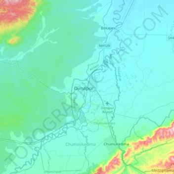
Name: Dimapur topographic map, elevation, terrain.
Location: Dimapur, Dimapur Sadar, Dimapur, Nagaland, 797112, India (25.75174 93.56170 26.07174 93.88170)
Average elevation: 204 m
Minimum elevation: 125 m
Maximum elevation: 770 m
Thank you for supporting this site ❤️
Make a donation
Make a donation
Gear up for your next adventure:
As an Amazon Associate, this site earns from qualifying purchases at no extra cost to you.