Geolocate

Vrindavan topographic map

Click on the map to display elevation.

👉 Easily get elevation data in JSON, GeoTIFF and KML formats using Elevation API
Thank you for supporting this site ❤️
Make a donation

Vrindavan

Vrindavan is situated on the west bank of the Yamuna River, about 15 kilometres north of Mathura. "Maps, Weather, and Airports for Vrindavan, India". www.fallingrain.com. Retrieved 6 December 2019.</ref> It has an average elevation of 170 metres (557 feet).

Wikipedia (CC-BY-SA 3.0)

About this map

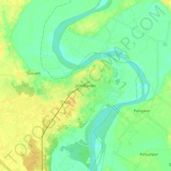
Name: Vrindavan topographic map, elevation, terrain.

Location: Vrindavan, Mathura, Uttar Pradesh, 281121, India (27.53537 77.65380 27.61537 77.73380)

Average elevation: 172 m

Minimum elevation: 161 m

Maximum elevation: 184 m

Other topographic maps

Click on a map to view its topography, its elevation and its terrain.

Chhata

India > Uttar Pradesh > Mathura

Average elevation: 184 m

Gear up for your next adventure:

💧Reusable Water Bottle - Durable water bottles for hydration on trails
💡Compact LED Flashlight - Powerful and portable flashlight for outdoor use
🧦Hiking Socks - Moisture-wicking and comfortable socks for long hikes
🔋Emergency Crank Radio - Weather alerts and power without needing batteries
🥾Hiking Shoes - Durable and comfortable shoes for trail hiking

As an Amazon Associate, this site earns from qualifying purchases at no extra cost to you.