Geolocate

Gresik topographic map

Click on the map to display elevation.

About this map

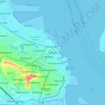
Name: Gresik topographic map, elevation, terrain.

Location: Gresik, East Java, Java, 61116, Indonesia (-7.19716 112.61596 -7.11716 112.69596)

Average elevation: 9 m

Minimum elevation: -7 m

Maximum elevation: 109 m

Other topographic maps

Click on a map to view its topography, its elevation and its terrain.

Situs Giri Kedaton

Indonesia > East Java > Gresik > Gresik

Average elevation: 40 m

Sungai Desa Sumput

Indonesia > East Java > Gresik > Driyorejo

Average elevation: 17 m

Telaga Kajen

Indonesia > East Java > Gresik > Kebomas

Average elevation: 41 m

Gear up for your next adventure:

🦯Trekking Poles - Reduced impact on joints for steep topographic climbs
💧Filtered Water Bottle - Safe drinking water on the go
🧦Crew Hiking Socks - Comfortable socks for long-distance hikes
🦶Anti-Blister Balm - Prevents friction and hotspots during long ascents
🩹Moleskin Blister Pads - Direct protection for painful foot pressure points

As an Amazon Associate, this site earns from qualifying purchases at no extra cost to you.