Geolocate

Kampung Perting topographic map

Click on the map to display elevation.

About this map

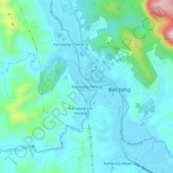
Name: Kampung Perting topographic map, elevation, terrain.

Location: Kampung Perting, Bentong, Pahang, 29700, Malaysia (3.50031 101.88577 3.54031 101.92577)

Average elevation: 154 m

Minimum elevation: 85 m

Maximum elevation: 510 m

Other topographic maps

Click on a map to view its topography, its elevation and its terrain.

Sungai Semantut

Malaysia > Pahang > Bentong

Average elevation: 174 m

Gear up for your next adventure:

🧣Merino Neck Gaiter - Protects against wind, sun, and cold at high altitudes
🐕Hiking Dog Pack - Let your canine companion carry their own water and food
🧼Travel Hand Sanitizer - Keep hands clean when water is scarce
🔭Compact Monocular - One-handed bird watching and trail spotting
🔭Outdoor Binoculars - Lightweight binoculars for birdwatching and hiking

As an Amazon Associate, this site earns from qualifying purchases at no extra cost to you.