
Brookville Township topographic map
Interactive map
Click on the map to display elevation.
About this map
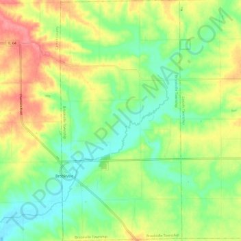
Name: Brookville Township topographic map, elevation, terrain.
Location: Brookville Township, Ogle County, Illinois, United States (42.02496 -89.68616 42.11274 -89.62632)
Average elevation: 262 m
Minimum elevation: 227 m
Maximum elevation: 310 m
Other topographic maps
Click on a map to view its topography, its elevation and its terrain.
Hillcrest
United States > Illinois > Ogle County
Hillcrest, Flagg Township, Ogle County, Illinois, United States
Average elevation: 251 m
Leaf River
United States > Illinois > Ogle County
Leaf River, Leaf River Township, Ogle County, Illinois, United States
Average elevation: 227 m